Travel Guide · Travel Guides · Updated August 2026
Vrindavan City Map: Where It Is, Layout and Temple Locations
By Gurudutt, Experience My India·22 August 2026
Quick Answer
Quick Enquiry
Key facts at a glance
Detail | Information |
State and district | Uttar Pradesh, Mathura district |
Region | Braj (Vraj), the land of Krishna |
On the India map | About 150 km south of Delhi, about 60 km north of Agra |
Coordinates | About 27.6 N, 77.7 E, on the west bank of the Yamuna |
From Mathura | About 15 km |
Parikrama Marg | About 10 to 11 km around the town |
Nearest railhead / airport | Mathura Junction (15 km) / Delhi (main), Agra (nearer) |
Vrindavan city map: an overview
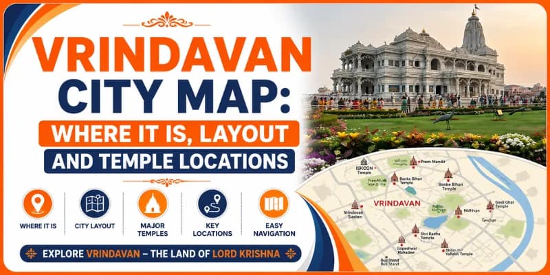
Arriving in Vrindavan for the first time, many pilgrims find the town a beautiful puzzle: a dense old core of narrow lanes by the Yamuna, ringed by the parikrama, with grand new temples spread out toward the highway. This guide is your map of Vrindavan, where it sits on the India map, how the city is laid out and where the temples, the ghats and the Parikrama Marg lie, so you can find your way. If you would like it all arranged for you, we run it as a mathura vrindavan tour package with a local guide who knows every lane.
Vrindavan is in the Mathura district of Uttar Pradesh, in the Braj region, on the west bank of the Yamuna, about 15 km from Mathura and about 150 km south of Delhi. This guide covers its place on the India map and its coordinates; the layout of the old town and the newer Chhatikara side; the Parikrama Marg and the Yamuna; where the main temples are; how to get around; and how to reach and plan. Our how to reach vrindavan guide covers arriving in the town.
From the ground (Gurudutt): The single most useful thing to hold in your head is that Vrindavan has two parts. The old town, by the river, is where the heart of the dham is, Banke Bihari, Radha Raman, Nidhivan, the ghats, all reached on foot through lanes too narrow for cars, so leave your vehicle at the edge and walk or take an e-rickshaw. The newer side, toward Chhatikara and the highway, is where the big temples are, ISKCON, Prem Mandir, Pagal Baba, with space and parking. If you keep those two zones clear on your mental map, you will never feel lost. A paper map or a phone map helps, but a local guide helps more, because the lanes are not always signposted. See our Mathura Vrindavan tour Package or message WhatsApp +91 7302265809.
Where is Vrindavan on the India map?
On the India map, Vrindavan lies in the north, in western Uttar Pradesh, in the Mathura district, in the Braj region that is revered as the land of Krishna's childhood. It sits at roughly 27.6 degrees north and 77.7 degrees east, on the west bank of the river Yamuna, at an elevation of about 170 m, about 150 km south of Delhi and about 60 km north of Agra, just off the Delhi to Agra route of the Golden Triangle.
So to place Vrindavan on the map: find Delhi, come about 150 km south along the Yamuna Expressway or the old Delhi-Agra highway and Vrindavan is beside its twin city Mathura, a little before Agra. The nearest railhead is Mathura Junction, about 15 km away and the nearest airports are Agra, the closer and Delhi, the main hub. So Vrindavan is south of Delhi, north of Agra, beside Mathura. Our places to visit near mathura guide covers the wider Braj around it.
The layout of Vrindavan: old town and the newer side
The map of Vrindavan falls naturally into two zones. The first is the old town, the ancient heart of the dham, a dense maze of narrow lanes running down to the Yamuna, holding the historic temples and the ghats; it is a place to walk, not to drive. The second is the newer side, spread along the Chhatikara road and the outer bypass toward the highway, holding the large modern temples, with wider roads, space and parking.
Chhatikara, on the highway, is the usual gateway into Vrindavan and the road from there passes the newer temples before reaching the old town by the river. So the old town is the riverside core, the newer temples the highway side, with Chhatikara the entry. So plan the old town on foot and the newer side by rickshaw. Our how to commute in vrindavan guide covers moving between the two.
The Parikrama Marg and the Yamuna
Ringing the whole of Vrindavan is the Parikrama Marg, the sacred circular path of about 10 to 11 km, walked barefoot by pilgrims as a circumambulation of the dham; it runs partly along the Yamuna and partly around the outer town and marks, in effect, the edge of the old town on the map. The river Yamuna runs along the eastern side of the old town and the historic ghats, above all Keshi Ghat, line its bank, where pilgrims bathe and the evening aarti is offered. Near the ghats and the old lanes lies nidhivan vrindavan, one of the most sacred groves of the town.
So the Parikrama Marg is the ring of pilgrimage around Vrindavan and the Yamuna with its ghats the sacred eastern edge. So both help you orient on the map. We present the sanctity of the parikrama and the Yamuna as the cherished belief and tradition of Braj, held with faith and recounted with reverence.
Where the main temples are
In the old town, near the Yamuna (walk): the beloved
banke bihari temple, the radha raman temple, the Radha Damodar and Radha Vallabh temples, Nidhivan and Seva Kunj and the ghats, all reached on foot through the lanes.
On the newer Chhatikara side (rickshaw): the grand
iskcon temple vrindavan, the prem mandir vrindavan, Pagal Baba, the Chandrodaya temple and Vaishno Devi Dham, with space and parking.
There are also the guardian Shiva shrines of the town, such as gopeshwar mahadev temple it might be noted, honoured across the dham. So the historic temples cluster in the old town and the grand new ones on the highway side. So use this as your temple map. Our mathura vrindavan temple timings guide covers the hours. We present the temples with the reverence of the tradition, held with faith.
Getting around Vrindavan
Within Vrindavan, the best way to get around is by cycle-rickshaw, e-rickshaw and on foot. The old town is a maze of narrow lanes where large vehicles cannot go and where the historic temples are best reached on foot; e-rickshaws link the old town with the newer Chhatikara side and the big temples and are cheap and plentiful. Larger vehicles are best left at the edge of the old town or at the temple car parks on the newer side.
So get around by rickshaw and on foot, especially in the old-town lanes. So keep your things secure and agree the fare first, as our commuting guide explains. So explore Vrindavan by rickshaw and on foot, the way the map of its lanes invites.
How to reach and plan
Reach Vrindavan via Mathura, about 15 km away and its nearest railhead or by road from Delhi (about 150 km, roughly 3 hours by the Yamuna Expressway) or Agra (about 60 km); the nearest airports are Agra and Delhi. The cool months of October to March are the most pleasant, covered in our best time to visit vrindavan mathura guide and our mathura vrindavan tour itinerary helps you shape the days. So reach Vrindavan via Mathura or by road from Delhi and Agra.
We arrange Vrindavan and Braj tours with a knowledgeable local guide who knows the map of the town, so you see the old town and the newer side in the right order without getting lost, with the transport and the routing timed around the darshan hours. A shared day tour starts from around ₹1,499 per person, with darshan free; our one-day vrindavan tour package covers Vrindavan and our two-day mathura vrindavan tour the twin cities. Message me on WhatsApp at +91-7302265809 to plan your visit to Vrindavan.
Related guides
Meet Gurudutt — Your Mathura Vrindavan Guide
Not just a tour operator — Gurudutt was born and raised in Braj Bhoomi. He has spent over a decade personally guiding pilgrims through the sacred lanes of Mathura & Vrindavan.
Founder – Experience My India
Gurudutt
Founder · Experience My India


%2520at%2520Govardhan.webp&w=1920&q=75)